
Since the 1950’s, the weekend drive 1-3 hours away from cities is a democratic automobile-driven North American custom involving the ritualistic exodus of urban populations from metropolitan centres to sacred landscapes, to worship natural monuments and recreate. This phenomenon is integral to the role that landscape plays in shaping Canadian Identity.
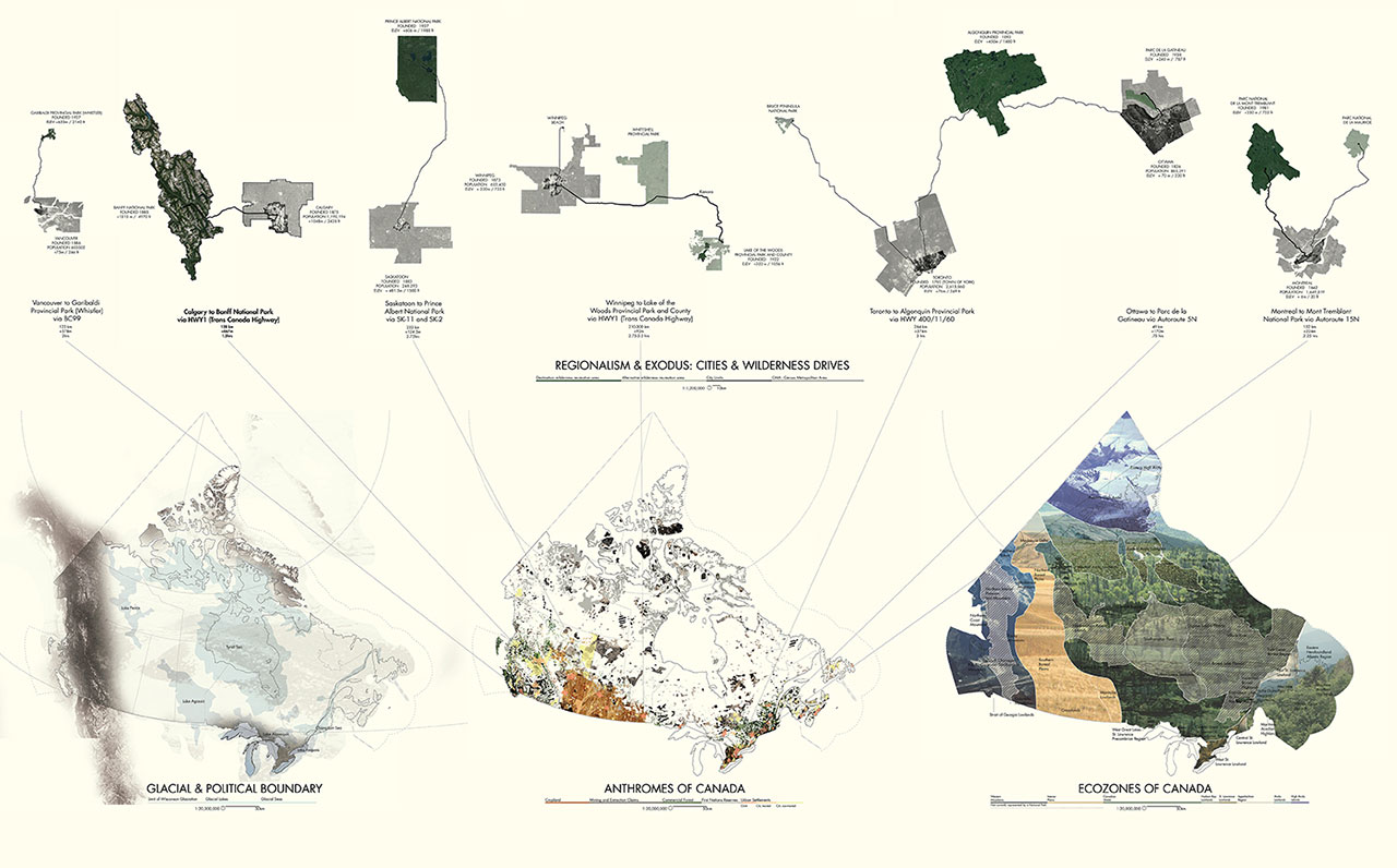
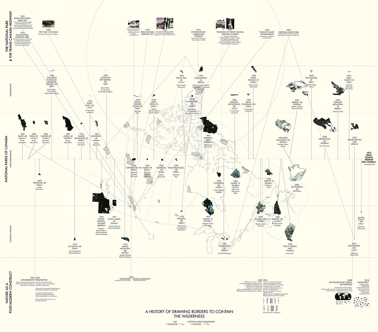
The national parks are a popular destination acting as living repositories of images of wilderness, with a mandate to represent each Canadian ecozone with a park. However, settlements, agricultural/productive landscapes, and resource landscapes are anthropogenic biomes – anthromes – which constitute a more accurate representation of national landscapes not currently recognized by any protected system.

National parks are nature anthromes themselves, bound by water, landform, or political boundaries. At a detailed design scale, the current landscape viewing experience in national parks reinforces a binary nature-as-other mentality. Bringing the national park relevance in the anthropocene demands a more holistic view of nature through the designation of anthromes as ecologically significant, and design of spatial experiences which implicate and involve human ecological processes.
The Trans-Canada Highway is a unique and nationally significant example of a vector in wilderness exodus which transects several major cities, all Canadian provinces, and a representative sampling of anthromes and ecological zones. The project site is a section of the TCH that connects Calgary and Banff, transecting five representative anthromes.
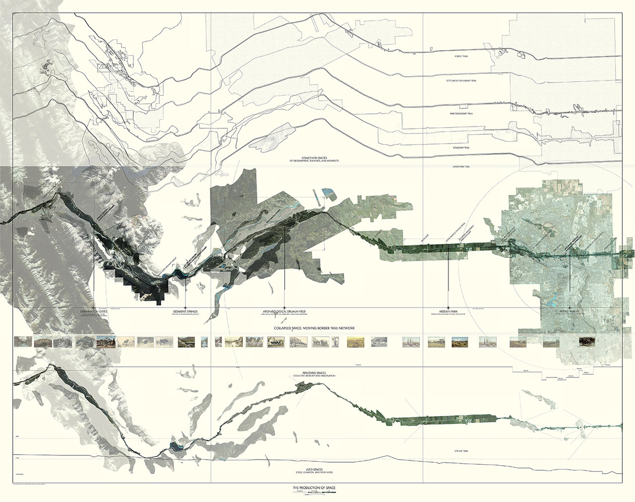
Using Henri Lefebvre’s “The Production of Space” as a framework for analysis, space is understood or produced in a combination of three ways:
The conceived space of designers delineates what is a city, park, or significant landform; the perceived space of imagination contains perceptions of pristine wilderness or idyllic agricultural settings; and the lived or experienced space of users operates at the scale and speed of the highway. These spaces are drawn respectively as layers of measured line drawings, postcards, and aerial/experiential imagery. Currently, the three types of space produce distinct readings, suggesting landscape architects can better mediate the problematic disparity between postcard nature and real nature by creating spaces that communicate more nuanced understandings of nature and wilderness concepts. 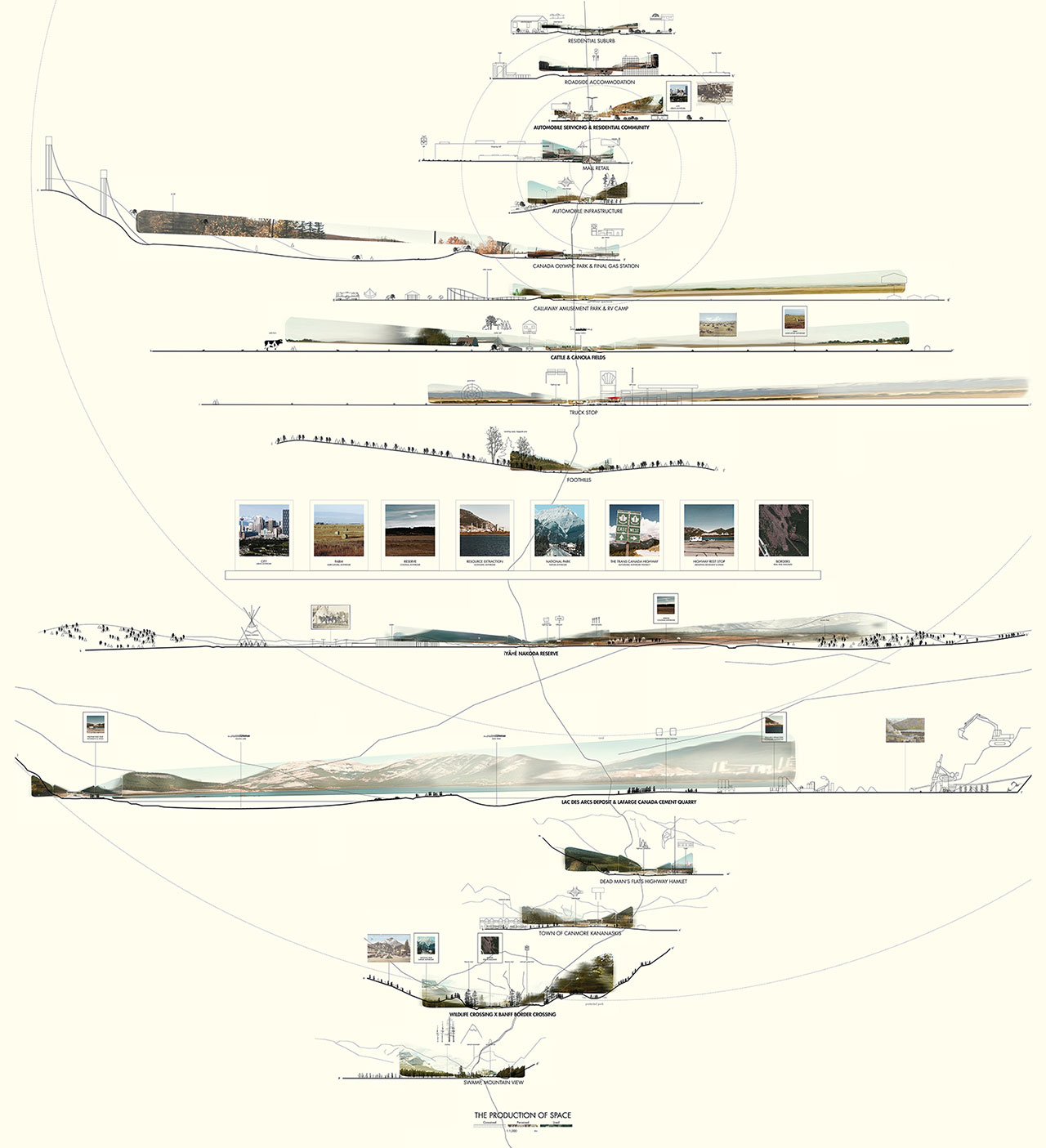
The master plan is a provisional trail map delineating multiple curated experiences along a continually changing border. The edge of the park refuses to prioritize a single species or land claim approach, instead involving visitors in contemporary integrated ecological management. Visitors crowdsource the boundary, populating the most desirable experiences, while simultaneously demarcating the boundary of the park.
This method succeeds traditional preservation/conservation approaches by recognizing that borders change with ecological flows and priorities of the people who use them. 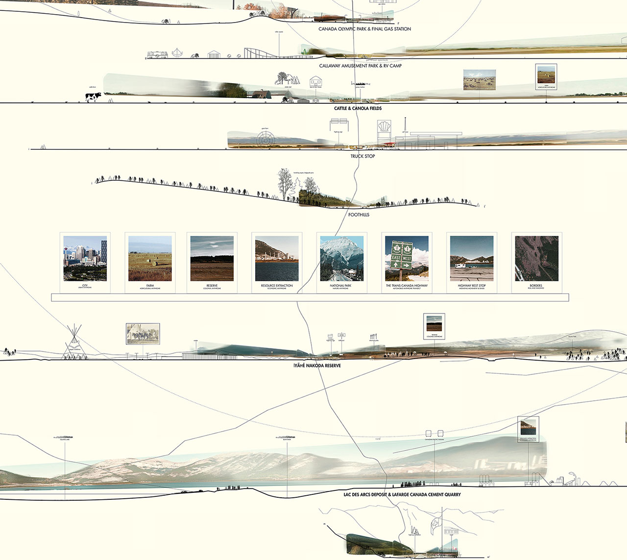
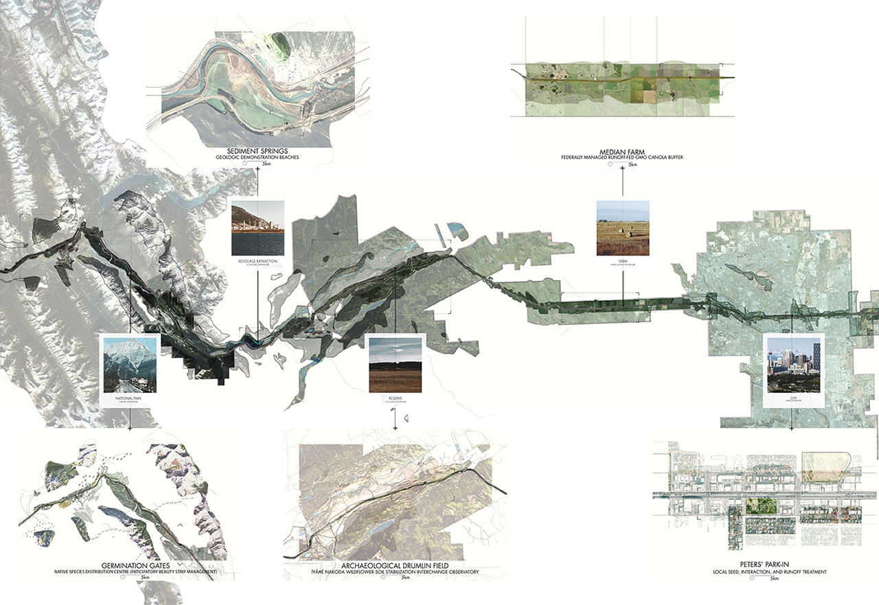
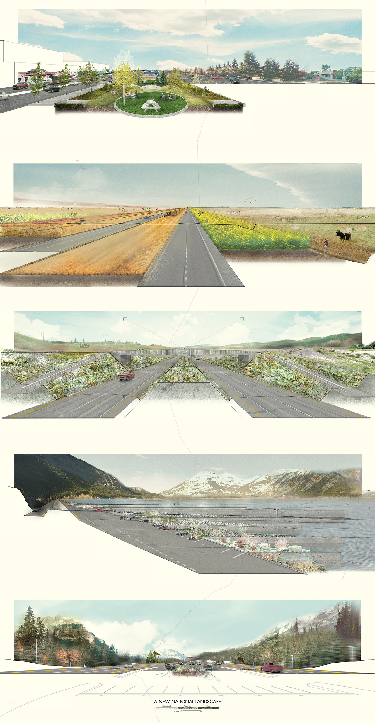
Five roadside viewing platforms for visitors to experience anthromes constitute the program for detailed design.
Peters’ Park-In
is a parking lot and picnic park for a historic drive thru that celebrates a decades-old burger joint popular with both locals and tourists, as a place for continued connections between people, the primary species in an urban ecology. A local vernacular of hardy urban species, such as Green Ashes blown over from Calgarian backyards, germinate in swales. Curbs and drains direct and store neighbourhood stormwater runoff to maintain three different types of grass in the park to correspond with usage intensity – empty lot germinators, sodded lawn, and artificial turf. 
Median Farm
divides the area of a 1 in 4 year planting cycle agricultural area into four linear productive median fields to support the cultivation of Canadian-invented cash crop Canola. The farm extends the length of the arable agricultural zone on the site, fed by highway runoff, acting as a federally managed productive buffer between GMO and non GMO farms to investigate the phenomenon of seeds blowing into neighbours’ fields. A border trail at the edge curates a muddy hike in a ha-ha ditch to view cultivated cattle in their natural environs. Cattle eat the dried canola stems, forming a complete food chain of Alberta farms. 
Archaeological Drumlin Field
depresses the highway up to 3m lower in the earth, removing it from the sight lines of first nations reserve citizens, while creating a compressed space for reflection by exposing the glacial till of the surrounding drumlin field. Constantly eroding steep gravel slopes are regularly stabilized with native and colonial flowers in a new poetic ritual of healing in a place with turbulent native and colonial history. Viewing areas of corrugated steel and reflective glass at interchanges reframe the highway as a scar cutting violently through the already marginalized reserve, acting as gateways to services that directly and respectfully support the local economy. 
Sediment Springs
foreground a lake formed by alluvial deposits and a historic cement plant. The geometries of an automobile pullout and linear concrete walls combine to frame views of cement and power plants. Between each wall, materials demonstrate the processes of deliberate erosion and ongoing sedimentation in a set of geologic beaches and pools. A succession of materials from stages of cement and concrete production meet accumulating Bow River sediment against cement jetties, all succeeded by hardy, self-seeding riverside plantings. 
Germination Gates
are anchored by a washing lot graded lower than the highway, freeing undercarriages and tyres of visiting vehicles from non-native species that might violate the protected park’s strict planting policy. Grooved asphalt impregnated with native seeds in the toll booth area supplant newly wetted tyres, where passing animals further their distribution. Instead of a threat, the car becomes a participatory vector in beauty strip management. Like the canola field and gravel slopes, this new conceived space collapses the perceptions of idyllic canola fields and lush forests with the lived experiences of the site, implicating and involving visitors in its production. 
Altogether, the five roadside viewing areas highlight integration of human process in nature to opportunistically produce new national landscapes. They intentionally reorganize views to frame postcard photographic moments of unique anthropomorphic biomes, to generate more multivalent understandings of identity and nature.

The reimagined Trans-Canada Highway demonstrates the emergence of a formidable new national park system, reframing the human migration network across North America as a place for operative roadside landscapes to affect positive ecological change, in practice, perception, and experience.

Trans-Canada Highway National Park
Location | Trans-Canada Highway between Calgary and Banff | |
Mostrar mensagens com a etiqueta alentejo. Mostrar todas as mensagens
Mostrar mensagens com a etiqueta alentejo. Mostrar todas as mensagens
Wilderness and Exodus: the Production of a National Landscape

Fulton Mall Rehabilitation Plans Spark Concerns

 Fulton Mall, 2010
Plans are underway for the reconstruction of Fresno’s Fulton Mall – an early example of an outdoor pedestrian mall, significant for incorporating into its design one of the first displays of public modern art outside of a campus/institutional setting. This Modernistcorridor, which showcases work by local and regional artists, was designed by landscape architect Garrett Eckbo and completed in 1964 as part of architect and urban planner Victor Gruen’s master plan for downtown Fresno. A 2013 Draft Environmental Impact Report (DEIR) with proposals that would threaten the integrity of the mall has raised concerns among members of The Cultural Landscape Foundation (TLCF), National Trust for Historic Preservation (NTHP), California Historical Society (CHS) and the California Preservation Foundation (CPF).

Fulton Mall, 2008, courtesy Tim Davis
As the city of Fresno has expanded outwards, it has seen the deterioration of its downtown core. This urban flight has led to high vacancy rates and the gradual disintegration of the public infrastructure. In August 2008, TCLF added Fulton Mall to its Landslide® list, in response to its diminished condition and ongoing discussion to open the pedestrian-only street to vehicles.
In 2010 the City of Fresno began a process to explore alternatives to invigorate the downtown spine, engaging experts and members of the public to create an option that was amenable to all parties as well as a transparent review process. The city assembled a team of consultants that met during a Fulton Corridor Specific Plan Community Advisory Committee Meeting (FCSPCAC) in September 2010. Discussion focused on the corridor’s six central blocks and adjacent cross streets. In a second meeting the public was presented with a series of design alternatives. Participants in this second meeting, a charrette called the Fulton Corridor Specific Plan Design Workshop, which was led by architect and urban designer Stefanos Polyzoides, included TCLF president Charles Birnbaum, preservationists and other consultants. Three separate tactics to address the mall’s deteriorated condition were examined: retain the corridor as pedestrian only; open the street up to vehicular traffic; or create a hybrid option, opening up some streets to vehicular traffic while maintaining the pedestrian core. Commentary from the workshop resulted in the production of ten alternatives that were presented to the FCSPCAC for a vote.


(upper) 2010; (lower) courtesy Tim Davis, 2008
The 21-member FCSPCAC, composed of residents, property and business owners, and experts in a variety of related fields, selected three of the ten concepts for further exploration during the environmental review process, though none featured a hybrid approach: 1. Reopen the street and remove the existing mall 2. Reopen the street keeping selected elements of the mall design as “vignettes”. 3. Restore the mall in its entirety. TCLF believes that none of these options represents a viable alternative and are instead a direct result of the city’s concern that a hybrid alternative may disqualify the project from receiving a specific federal transportation grant. Additionally TCLF believes that moving forward with the specified options could threaten the site’s eligibility for National Register of Historic Places listing.
Birnbaum developed a whitepaper during the charrette process that argued for a hybrid alternative, stating: “As discussed during the charrette, the idea of opening some of the cross streets to vehicular traffic has great merit. For example, in Charlottesville, VA two of the cross streets along the eight block mall have successfully been opened in recent years…” He goes on to issue a warning about the delicacy of such an approach: “In general, by opening the Mall to moving/parked vehicles there is a diminished integrity of design. These changes to accommodate vehicles will need to be viewed on a case-by-case basis, ideally guided by a set of overarching design principles that balance use, design and historic preservation.”
In response to these concerns The Cultural Landscape Foundation, National Trust for Historic Preservation, California Historical Society and the California Preservation Foundation provided their comments on the DEIR to Elliott Balch, Downtown Revitalization Manager of the City of Fresno. The letter, dated January 13, 2014, emphasized the need to consider a hybrid alternative stating: “The Coalition would very much like to see the City of Fresno take positive steps to reinvigorate its historic downtown, and to sensitively redevelop the Fulton Mall as a part


(upper) courtesy Tim Davis, 2008; (lower) 2010
of that process. We believe that the City has the clear authority to adopt a hybrid alternative that will not compromise the integrity of the Fulton Mall to a degree that it would be ineligible for the National Register. Further, because several alternatives were analyzed in the DEIR, but rejected, selection of such an alternative will not require re‐circulation of the DEIR.”
Peavey Plaza Nomination Gets the Go-Ahead
The future of Peavey Plaza has taken a strategically significant turn for the better. The site, which was previously determined eligible for listing in the National Register of Historic Places, is proceeding along to actual designation.
On November 5, 2012, the Minneapolis Heritage Preservation Commission, which had previously voted 8-1 to delay Peavey’s demolition, voted to recommend Peavey’s listing in the Register. Then, on November 13, the Minnesota State Review Board concurred in a unanimous vote. The application has been sent to the National Park Service for a final determination, which is due within 45 days of receipt.
Designation is important because the City of Minneapolis and the Minnesota Orchestra have disputed the plaza’s significance in arguing there are no alternatives to Peavey’s demolition. Designation would also bolster a lawsuit to preserve Peavey based on the Minnesota Environmental Review Act (which was the basis of a 1993 decision to prevent the demolition of the Minneapolis Armory building because of that site’s historic and architectural importance). In a November 16, 2012, Finance & Commerce article, University of Minnesota Law School professor Alexandra Klass said: “The law protects historic resources that are unique, or that have historic significance that would be endangered if they were removed or changed. That seems to be the significant element here.” Having Peavey listed in the National Register of Historic Places helps make that point.

Arquitetura paisagista nas melhores cidades do mundo
Você sonha em morar em outros países para ganhar qualidade de vida? E quando imagina estes lugares, você já se perguntou se eles são realmente bons? A revista americana The Economist mantém um ranking com as melhores cidades do mundo que pode mudar seu conceito sobre algumas delas. Centros urbanos populares como Londres, Paris, Nova York ou Tóquio nem sequer estão entre as 15 mais bem colocadas. No lugar delas, cidades da Austrália e do Canadá ocupam sete dos dez primeiros lugares.
O ranking é baseado em estabilidade saúde, cultura, desenvolvimento, educação e infraestrutura. A pesquisa avaliou 140 cidades. As melhores tendem a ser de tamanho médio e estar em países ricos, com baixa concentração populacional. Estas condições permitem um grande número de atividades recreativas, baixos níveis de criminalidade e nada de infraestrutura sobrecarregada. Melbourne já havia sido a vencedora no ano passado. A Austrália tem sido alvo de grandes investimentos federais em infraestrutura desde 2010. Já Vancouver, no Canadá, a terceira colocada, foi alvo de várias ações em 2012 para melhorar o trânsito.
Tóquio, no Japão, ocupa o 18º lugar, Hong Kong, na China, o 31º, Londres, na Inglaterra, o 53º, Nova York, nos Estados Unidos, o 56º e Nova Déli, na Índia, o 102º. Na última posição, está Dhaka, em Bangladesh. A pesquisa é feita pela consultoria Economist Intelligence Unit. Fotos da Shutter Stock.

1. Melbourne, Austrália

2. Viena, Áustria

3. Vancouver, Canadá

4. Toronto, Canadá

5. Calgary, Canadá

6. Adelaide, Austrália

7. Sydney, Austrália

8. Helsinki, Finlandia

9. Perth, Austrália

Melhores jardins privados de 2012


Fotografia: Scott Frances
Na base da Table Mountain na Cidade do Cabo, surge um dos jardins privados premiados este ano pela ASLA (American Society of Landscapes Architects), do atelier de arquitectura paisagista e interiores Rees Roberts and Partners.


A integração do jardim na paisagem usando maioritariamente vegetação nativa, demonstra também a biodiversidade natural da região. Um jardim onde ecologia, sustentabilidade e design se juntam para criar espaços interessantes e de uma beleza única.


Foi destacado pela a ASLA pela sua contextualização ecológica. Com cerca de 1750 m² tem como ponto focal a piscina natural. Com processos de filtragem completamente naturais e ecológicos , a água é depois bombeada para um lago, passa pelo interior da casa e novamente para o exterior numa série de cascatas, em simultâneo oxigenando a água que antes de chegar novamente à piscina passa por uma zona de regeneração onde a plantas fazem naturalmente uma última filtragem.


Especialistas também em interiores, Rees Roberts and Partners, tornaram a casa e um jardim num único espaço trabalhando estas duas zonas ao mesmo tempo e utilizando o mesmo conceito, unificando todo o projecto.


Ficha Técnica:
DesignerRees Roberts + Partners LLC
David Kelly, ASLA, Partner
David Kelly, ASLA, Partner
ArquitectoAntonio Zaninovic
InterioresRees Roberts + Partners LLC
Lucien Rees Roberts
Lucien Rees Roberts
Consultores horticulas e paisagistas
Beyer Honig Landscapes
Bruce Beyer and Marijke Honig
Beyer Honig Landscapes
Bruce Beyer and Marijke Honig
Instalação da Piscina Natural
aQua-design
Jerome Davis
aQua-design
Jerome Davis
Construtor
Paul Wolpert
Paul Wolpert
Selecção do Mobiliário Exterior
Rees Roberts + Partners LLC

O festival de jardins mais famoso do mundo comemora em 2013 - Chelssa Flower Show
O
festival de jardins mais famoso do mundo comemora em 2013 o seu centenário e a
Ecossistemas, em colaboração com o Ecoviveiros, vai lá estar para
falar com alguns dos melhores designers. Mas antes fazemos aqui uma pequena
mostra dos jardins que irão estar em exposição.
 |
|
Jardim
« The Brewin Dolphin Garden»
Expositor:
Brewin Dolphin
Designer(s):
Robert Myers
|
.jpg) |
|
Jardim
« The SeeAbility Garden»
Expositor:
SeeAbility & Coutts
Designer(s):
Darren Hawkes
|
 |
|
Jardim« The Laurent-Perrier Garden »
Expositor: Laurent-Perrier
Designer(s): Ulf Nordfjell
|
 |
|
Jardim
« Trailfinders Australian Garden presented by Flemings»
Expositor:
Fleming’s Nurseries
Designer(s):
Phillip Johnson
|
Subscrever:
Comentários (Atom)